Pic de Bénou 2267m - 12 May 2013

I really like this peak. It has a very direct descent to Astún and a very appealing slope at the summit. But life isn’t just about climbing mountains. People´s lives change. Just as bullfighters retire from the scene, snowboarders worry more about their life and less about their flow. ‘Flow’? What is ‘flow’? I think I know what it is, but I can´t explain it. You have to feel it. My friend, Luis Alcaraz, who knows quite a lot about this, tells me that there is something comparable in bullfighting that they call ‘duende’. Whatever ‘flow’ might be, I know that it’s less important to me these days. If you think you know why this might be, why not post a comment below?

Este pico me gusta mucho. Tiene un descenso muy directo hasta Astún y una pala somital muy apetecible. Pero no todo en la vida es subir montañas. La vida de las personas cambia. Al igual que los toreros se cortan la coleta, los snowboarders se empiezan a preocupar más por su vida y menos por su flow. El flow... ¿Qué es el flow? Creo que lo sé, pero no puedo explicarlo. Hay que sentirlo. Mi amigo Luis Alcaraz, que sabe bastante sobre este asunto, me ha dicho que en tauromaquia existe algo comparable que llaman duende. Sea lo que sea el flow, ya no me importa tanto. Si alguien cree que tiene que ver algo con esto, que escriba un comentario abajo.

Culivillas 2509m - 11 May 2013

I first set eyes on this mountain in May 2010 and three years later I climbed it with Eamon McMahon, who took the photo you can see here. Fortunately, there has been plenty of snow on the Pyrenees in 2013 and so we were able to descend without problems until Anayet car park, in Formigal ski resort. And that’s it; another one for the bag. I like to achieve my objectives, it gives me more and more experience and better judgement to face new challenges.

En mayo de 2010 puse mis ojos en esta montaña y tres años después la subí con Eamon McMahon, que fue quien hizo la foto que aquí se puede ver. Afortunadamente, en 2013 ha habido mucha nieve en los Pirineos y por eso pudimos bajar sin problema hasta el parking de Anayet, en la estación de esquí de Formigal. Así que nada… otro pico para la buchaca. Me gusta ir completando objetivos, ello hace que cada vez tenga más experiencia y capacidad de análisis para afrontar nuevos retos.

Testa Grisa 3060m - 4 May 2013

This day we could have ascended the Northeast face of Mont Vélan, a much more significant mountain than this one, but we didn't do it because we were expecting bad weather. A webpage some local guides trusted said it was going to be a bad day, another one said it wasn't. You can't trust weather forecasts 100%; that's what I learnt on this trip. Even so, there was a reward to be had for climbing this mountain: I could see and point at the West face of Mont Vélan. Hannibal's couloir, which I hope I can descend one day, can be found there. I think it will be one of those descents without compare.

Este día podríamos haber subido la cara Noreste del Mont Vélan, que es una cima con mucha más entidad que esta, pero no lo hicimos porque esperábamos mal tiempo. Una página web en la que algunos guías locales confiaban decía que haría malo, otra decía que no. Uno no se puede fiar al 100% de las predicciones meteorológicas, eso es lo que aprendí en este viaje. De todas formas subir a esta cima tuvo una recompensa: pude ver e indicar con mi dedo la cara Oeste del Mont Vélan. Ahí está la canal de Aníbal, la cual espero poder bajar algún día. Creo que será uno de esos descensos sin par.

Espigüete 2451m - 21 April 2013

My intention was to descend the North face of this mountain. It’s a good 851 metres of vertical drop there, with a good couloir and good slopes. The melting-refreezing process is common at this time of the year and so I decided to begin the ascent late. I set off at 13:30 but the hardness of the snow in some exposed places of the North face made me change my plans. For safety reasons, I decided to descend the South face, where soft, wet snow was guaranteed. This had several consequences. The first one was that I didn´t feel the need to cross myself up there: a couple of deep breaths were enough. The second was that the descent was shorter than I had expected: I had to be satisfied with a vertical drop of about 600 or 700 metres. The third was the most painful, as the way back with the snowboard on my back was longer than expected: instead of the 3 kilometres I had planned along a comfortable path, I had to do more than 6 kilometres crossing areas with dense vegetation (the icing on the cake on a Sunday evening before the long drive back to Madrid).

Mi intención era bajar la cara norte de esta montaña. Ahí hay unos buenos 851 metros de desnivel, con una buena canal y sus buenas pendientes. A estas alturas del año es común el proceso diario de deshielo-rehielo y por ello decidí empezar a subir tarde. Empecé a caminar a las 13:30 pero la dureza de la nieve en algunos lugares expuestos de la cara Norte me hizo cambiar de planes. Por seguridad decidí bajar por la cara Sur, donde la nieve húmeda y blanda estaba garantizada. Ello tuvo varias consecuencias. La primera fue que no vi la necesidad de santiguarme allí arriba: bastó con un par de respiraciones profundas. La segunda fue que el descenso fue más corto de lo que había previsto: me tuve que conformar con un desnivel de unos 600 o 700 metros. La tercera fue la más dolorosa, ya que el camino de vuelta con la tabla a la espalda fue más largo de la cuenta: en lugar de los 3 kilómetros que había previsto por un cómodo sendero tuve que hacer más de 6 kilómetros atravesando zonas de espesa vegetación (la guinda perfecta para un Domingo antes de chuparme una buena kilometrada hasta Madrid).

Peña Ubiña 2411m - 20 April 2013

I always wanted to go to the Cordillera Cantábrica to snowboard and I think this mountain was a good choice. I had already had a good feeling about it when I visited it in summer. The descent from the summit to Meicín Hut is direct, with a vertical drop of 861 metres and steep slopes that exceed 45 degrees in places. If you are an experienced snowboarder/skier I would highly recommend it, although you have to be careful with the barbed wire on the Southeast face at a height of 2000 or 2100 metres. The best thing is to try to see it on the ascent to avoid an unpleasant situation on the way down because it can be really dangerous.

Siempre quise ir a la Cordillera Cantábrica a hacer snowboard y esta montaña creo que fue una buena elección. Cuando la visité en verano ya me dio buenas sensaciones. El descenso desde la cumbre hasta el Refugio del Meicín es directo, con un desnivel de 861 metros y pendientes fuertes que llegan a sobrepasar los 45 grados. Creo que es muy recomendable si eres un snowboarder/esquiador experimentado, aunque hay que tener cuidado con el alambre de espino que hay en la cara Sureste a una altura de 2000 o 2100 metros. Lo suyo es intentar verlo durante la subida para evitar situaciones desagradables en la bajada porque puede ser realmente peligroso.

Valdemartín 2282m - 14 April 2013

Descending this mountain on the Cerradillas bowl is OK, but it’s a bit out of the way. I mainly climbed it for the sake of training and to add another entry to this growing blog which could become extremely large. I don’t know how far it will go, but it seems set to continue as I still intend to climb more mountains. One day that will come to an end though… And what will happen then?

La bajada de esta montaña por el circo de las Cerradillas está bien, pero pilla un poco a desmano. Subir a esta montaña fue mayormente una cuestión de entrenamiento y de coleccionismo. Este blog es una colección que puede llegar a ser tremendamente grande… no sé hasta dónde llegará. Sí puedo decir que todavía tengo intención de subir algunas montañas, así que esto no parece que de momento vaya a parar. Pero llegará un día en el que pare… ¿Y qué pasará ese día?

Montardo 2833m - 29 March 2013

The attempt to climb this mountain was a complete failure. We got off to a bad start, setting off late, and the highest point we reached was Lac de Saslòses, which we never intended to go to. From there, it didn’t look easy to ascend to Montardo. Furthermore, the day began clear but clouded over little by little. Finally, the high temperature made the snow too wet and heavy. In the photo you can see my partner Ricardo Fanjul, just at the beginning of the retreat, when we descended the couloir where Lac de Saslòses feeds the valley at other moments of the year. At least I can say that we had a good, intense descent there.

El intento de subir a esta montaña fue un rotundo fracaso. Empezamos a caminar tarde y lo más alto que llegamos fue el Lac de Saslòses, al cual nunca quisimos ir. Desde ahí no se veía fácil subir al Montardo. Además el día empezó soleado pero poco a poco se fue nublando. Por último, la temperatura elevada puso la nieve demasiado húmeda y pesada. En la foto se ve a mi compañero Ricardo Fanjul, justo al principio de la retirada, cuando bajamos la canal por la que el Lac de Saslòses da sus aguas al valle en otros momentos del año. Al menos fue intenso bajar por ahí.

Tuc de Barlonguèra 2802m - 3 March 2013

It was hard for me to choose a photo of this great mountain in Vall d’Aran because I have so many beautiful ones, both taken from it and of it. I like to display this image full screen and listen the track “Troops of Doom” by Sepultura (Tomb) at full blast. I have been on this summit twice and on neither occasion could I see the slightest sign of human life. I couldn’t even see the geodesic vertex there. Everything was completely covered by the pristine snow.
You arrive at the summit ridge… and the silence, the fear, the unparalleled views and your own determination fill every second. And then you appreciate, for a fleeting moment, just how marvellous what you do is, be it for better or worse. My first descent of the mountain was on 3 March 2013 from the first pass to the East of the summit (at a height of 2687 metres) and the second one was on 31 March 2013 from the very summit, heading south. An extremely important moment in my life took place on this second descent. I think it was an example of one of those moments that, if what they say is true, come back to a person later, when they feel that they are approaching death. If that’s true, then I hope it doesn’t come back to me later. Although I do hope to see my friend Ricardo Elviro again, with whom I cannot fail to have a special connection. He knows why.

Me ha costado mucho elegir una foto para esta gran montaña del Vall d´Aran porque tengo muchas imágenes bonitas de ella y desde ella. Esta foto me gusta ponerla a pantalla completa y escuchar la canción de Sepultura que se llama “troops of doom” a todo trapo. He estado dos veces en esta cumbre, nunca vi rastro humano. No vi el vértice geodésico que hay allí. La nieve inmaculada lo tapó todo.
Llegas a la arista somital… silencio, miedo, vistas sin par y determinación inundan cada segundo. Ahí vislumbras la grandeza de lo que haces, para bien o para mal. Mi primer descenso de esta montaña fue el 3 de marzo de 2013 desde el primer collado que hay al este de la cumbre (a 2687 metros de altura) y el segundo fue el 31 de marzo de 2013 desde la mismísima cumbre y en dirección sur. Esta segunda vez fue un momento importante de mi vida, creo que de esos que dicen que se te aparecen cuando estás en una situación próxima a la muerte. Si eso que dicen es verdad, espero que ese momento no se me aparezca de nuevo. Sí espero ver de nuevo a mi amigo Ricardo Elviro, con quien creo que será imposible no tener una conexión especial, él sabe por qué.

Tuc deth Dossau 2518m - 2 March 2013

You can ascend this mountain by chairlift and that´s what I’ve always done. Of the two descents I´ve done far from the ski slopes, I would only recommend one: the one that begins on the summit, direction Northwest along Barranc de Laveja. It is a very direct descent, free of pine trees. It takes you to Bonabé track, which takes you rapidly to Montgarri hut. The problem with this descent is that it seems to be a natural path for avalanches, so you have to be careful. The other descent I did, along Bòsc deth Dossau and Cant dera Cremada, is very craggy and this can prevent you from descending directly and easily force you to take your snowboard off and go back. There are steep slopes, potentially with lots of powdery snow, so the retreat can be awful.

A esta montaña se puede subir en telesilla y yo siempre lo hice así. De las dos bajadas que he hecho lejos de las pistas solo recomendaría una: la que sale desde la cumbre en dirección Noroeste por el Barranc de Laveja. Se trata de una bajada muy directa y libre de pinos. Te lleva hasta la pista de Bonabé, con la que enseguida se llega al refugio de Montgarri. El problema de esta bajada es que parece ser que es camino natural de avalanchas, por lo que hay que tener precaución. Por la otra bajada que hice, por el Bòsc deth Dossau y el Cant dera Cremada, hay grandes riscos que impiden un descenso directo y fácilmente te obligan a quitarte la tabla y retroceder. Es un lugar con fuertes pendientes que se pueden unir a grandes cantidades de nieve suelta, con lo que el retroceso puede ser verdaderamente penoso.

Séptimo Pico 2138m (second part) - 24 February 2013

As can be seen in the photo, this mountain has a really beautiful North face, though I would readily give it, or any other face like it, to have my friend, Arturo Navas, back. He lived at the foot of this mountain for a few years and I’ve dedicated this entry to him. Those were the years of our adolescence. Happy adolescence. He died on 2 November 2012 in the Ravine of Los Carrizales (Tenerife Island) in a tragic accident, when he was just 36 years old. He was one of those friends you always want to have around on special occasions. When I remember the good times we spent together, a dark cloud passes over my heart. Life is short and fragile. And it is not fair. But we have to enjoy it because it is, at the end of the day, the only thing we have for sure.

Como puede verse en la foto, esta montaña tiene una cara norte realmente bonita, aunque la cambiaría por mi amigo Arturo Navas sin dudar. A él le dedico esta entrada. Él vivió por unos años al pie de esta montaña. Esos fueron años de adolescencia, feliz adolescencia. Murió el 2 de noviembre de 2012 en el barranco de Los Carrizales (isla de Tenerife) por un desgraciado accidente, cuando tenía una edad de tan solo 36 años. Era de esos amigos con los que quieres contar en las fechas señaladas. Se me ensombrece el alma al recordar los buenos momentos que pasamos juntos. La vida es corta y frágil. La vida no es justa. Hay que disfrutar de la vida, es lo único que tenemos seguro.

Unnamed peak 5120m - 20 July 2012

During my visit to Pamirs I had plenty of time to think. The acclimatization process takes time. You spend whole days in the camps. In fact, the time you spend ascending or descending is small compared to the periods of inactivity. That’s what big mountains are like. One thing in particular that I had time to reflect on was whether Lenin Peak was really worth having a go at, with everything involved: the risk, remoteness, difficulty and long acclimatization period. In my attempt to quantify how good a mountain might be to snowboard down, many factors came to mind and, as I returned to Spain, I devised a coefficient of suitablility. It’s like giving a score to each mountain. How absurd! Feelings aren´t objective though, thank God. I like the suitability coefficient because it informs, it’s my creation and I’ve never heard of anything like it before. Even so, I prefer gut feelings and so I guess I’ll just keep tackling the mountains I fancy having a go at, provided I feel I’m up to them.
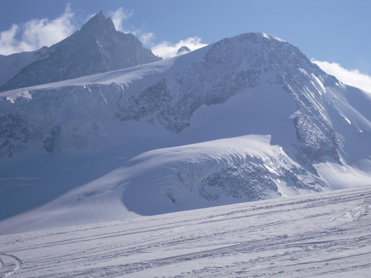
I did fancy ascending this mountain. I don’t know if it has a name by the way. It´s small compared to the ones around it, but it offers a vertical drop of a thousand skiable metres if you attack its North face. I climbed its East face because this was more at hand, but the problem was that to reach the summit that way, you have to go along an uncomfortable crest that I didn´t want to face. This way I suffered my second defeat in Kirghizstan. Two attempts; two defeats. A good dose of humility is never a bad thing to remind us that we shouldn’t go to the mountain expecting success. I’ve been defeated so many times now that it affects me less and less and I know that it makes me appreciate the victories more.

En mi visita al Pamir tuve mucho tiempo para pensar. El proceso de aclimatación lleva su tiempo. Se pasan jornadas enteras en los campamentos. De hecho, el tiempo que se pasa subiendo o bajando es pequeño si se compara con el tiempo de inactividad. Las grandes montañas son así. Una de las cosas que más medité fue si valía la pena intentar el Pico Lenin, con todo lo que ello conlleva: riesgo, lejanía, dureza y largo periodo de aclimatación. En mi intento de cuantificar la bondad de una montaña para su descenso con snowboard barajé todos los factores que me vinieron a la cabeza y, a mi vuelta a España, inventé el coeficiente de idoneidad. Es como poner una nota a cada montaña. ¡Qué absurdo! Las sensaciones no son objetivables, gracias a Dios. Me gusta el coeficiente de idoneidad porque da información, es mi creación y nunca oí hablar de algo así antes. Aún así, más me gustan las sensaciones y, por ello, subiré las montañas que pueda y me apetezca, si me apetece.
Subir a esta montaña, de la que desconozco si tiene nombre, sí me apeteció. Es pequeña si se compara con las de su alrededor, pero ofrece mil metros de desnivel esquiable si se ataca su cara Norte. Yo subí su cara Este porque me pillaba más a mano, pero el problema fue que para llegar a la cima por ahí hay que recorrer una cresta incómoda que no quise afrontar. De esta manera conseguí mi segunda derrota en Kirguizstán. Dos intentos, dos derrotas. Un buen baño de humildad nunca viene mal y nos recuerda que a la montaña hay que ir sabiendo que se puede perder. Yo ya he perdido tantas veces que cada vez me afecta menos y ahora valoro más las victorias.

Razdelnaya 6148 m - 17 July 2012

I went to Kirghizstan with the intention of ascending Lenin Peak, which is a thousand metres higher than this one, but it wasn´t possible. As soon as I got to the country I made two basic mistakes: I drank water from a tap and ate something similar to a kebab in the first place I came to in Bishkek. My stomach wasn´t prepared for it and I immediately suffered the unpleasant symptoms of acute gastroenteritis. In spite of this I set off towards Osh and then to base camp, but after two nights there I decided to go back to Osh because I felt really bad, vomiting and with stomach pains. I spent four nights there and managed to recover, so I decided to go back to base camp again, but knowing that I wouldn´t have time to climb Lenin Peak because I had lost too many days. Anyway, ascending Razdelnaya was an extraordinary experience, mainly because of the views I was able to enjoy. It was possible to see a sea of mountains that I don´t think I will ever forget. I don´t think that I will forget my first night in camp 2 either, under intense snowfall and a strong blizzard. I had to get up at midnight to take the shovel and dig the tent out a bit and I found myself feeling strange, looking up at the moon in the middle of the darkness, with a slight headache due to the altitude and so far from the comforts of Gandía beach. A few hours later there were morning avalanches that I could hear but not see from inside the tent. One of the falls made a very loud noise and was accompanied by a notable air impact. When I felt that impact I thought it was the end. That´s the truth. But it wasn´t the end, thank God.

Fui a Kirguizstán con la intención de subir el pico Lenin, que es mil metros más alto que este, pero no pudo ser. Según llegué al país cometí dos errores básicos: bebí agua del grifo y comí algo parecido a un kebap en el primer sitio que encontré en Bishkek. Mi estómago no estaba preparado para esto e inmediatamente sufrí los desagradables síntomas de la gastroenteritis aguda. Pese a ello partí hacia Osh y luego para el campo base, pero después de dos noches allí decidí volver a Osh porque me encontraba realmente mal, con vómitos y dolor de estómago. Allí pasé cuatro noches y pude recuperarme, así que decidí volver al campo base de nuevo, pero sabiendo que no me daría tiempo a subir al pico Lenin porque había perdido demasiados días. En cualquier caso subir al Razdelnaya fue una experiencia única, sobre todo por las vistas que pude disfrutar. Se veía un mar de montañas que no creo que olvide nunca. Tampoco creo que olvide la primera noche que pasé en el campo 2, bajo intensa nevada y fuerte ventisca. Tuve que levantarme a media noche para coger la pala y desenterrar la tienda un poco y sentirme extraño mirando la luna en medio de la oscuridad, con algo de dolor de cabeza por la altura y tan lejos de las comodidades de la playa de Gandía. Unas horas después hubo avalanchas mañaneras que oía pero no veía desde el interior de la tienda. Uno de los desprendimientos sonó muy fuerte y vino acompañado por un impacto de aire notable. Al notar dicho impacto pensé que era el fin, esa es la verdad. Pero gracias a Dios no fue el fin.

Gran Paradiso 4061m - 2 May 2012

I climbed this mountain on 2 May, 2012, after intense snowfalls had accumulated which could be called a ‘big dump’: around 30 or 40 centimetres of new snow. When I got to a height of 3700 metres the sun appeared and I saw the summit as it appears in the photo. Opening up a track in such deep snow over a total rise of about a thousand metres is no small thing and I pulled muscles in both legs. Even so, I managed to endure it until the end and get to the top. Then the cloud came back and it started to snow, at which point I began to hear long, deep sounds around me. They sounded like an aeroplane flying high above but I soon realized they were avalanches, invisible to me because of the cloud cover. It was disturbing, to say the least; up there alone, unable to see much at all, with the snow falling around me. Booom…booom…. I descended following my ascent track, with very good snow, but thinking more about arriving at the hut than anything else.

Subí a esta cumbre el día 2 de mayo de 2012, tras intensas nevadas que acumularon lo que se puede llamar un paquetón: unos 30 o 40 cm de nieve nueva. Cuando llegué a una altura de 3700 metros apareció el sol y vi la cumbre como puede verse en la foto. Subir un desnivel de unos 1000 metros abriendo huella en nieve tan profunda no es poca cosa y me dieron tirones en ambas piernas. Aún así aguanté hasta el final como pude. Llegué hasta arriba. Fue entonces cuando volvió la nube, empezó a nevar y oí largos y graves sonidos a mi alrededor. Eran sonidos parecidos al de un avión volando alto, pero pronto comprendí que eran avalanchas que la nube que me cubría no me permitía ver. La sensación era inquietante como mínimo. Allí solo, sin ver un comino, nevando, buuummmmmm, buuuuuummmmmm. Bajé siguiendo mi huella de subida y con muy buena nieve, pero pensando más en llegar al refugio que en otra cosa.

Cambre D´Aze 2750m - 22 April 2012

Things didn’t look very promising when I started to climb this mountain from the French village of Saint Pierre del Forcats. There were low clouds and the visibility was dreadful, but as I gained height the clouds gradually lifted, giving me the good fortune that, as I reached the summit, they finally gave way to the sun and I had unforgettable views. Moreover, I could descend the central couloir with reasonable visibility and good dry snow, something which wasn’t to be expected as it was well into April (22 April, 2012). Only two traces can be seen in the photo, both mine: the one I made as I struggled to open up the track in the deep snow and the descent, which gave me real satisfaction and literally made me whoop with joy. Eight hours later I was back in Madrid, feeling that cities simply weren’t built for me.

La cosa no pintaba bien cuando empezé a subir esta montaña desde el pueblo francés de Saint Pierre dels Forcats. Había nubes bajas y pésima visibilidad, pero a medida que fui cogiendo altura se fueron levantando las nubes paulatinamente, con la suerte de que al llegar a la cumbre las nubes dieron paso al sol y tuve vistas inolvidables. Además pude bajar la canal central con visibilidad y buena nieve seca, cosa que yo no esperaba porque el mes de abril ya estaba bien avanzado (esto fue el 22 de abril de 2012). En la foto solo se ven dos huellas, ambas mías: la que trabajosamente dejé al abrir huella en la nieve profunda en la subida y la de bajada, que me provocó verdadera satisfacción y gritos de dicha. Ocho horas después estaba en Madrid, sintiendo que la ciudad no está hecha para mi.

Puigmal 2911m - 21 April 2012

I climbed this Pyrenean mountain on 21 April, 2012. There are many things I could say, but I’ve chosen this quote from Macbeth as protagonist of this entry: Tomorrow, and tomorrow, and tomorrow, creeps in this petty pace from day to day, to the last syllable of recorded time; and all our yesterdays have lighted fools the way to dusty death. Out, out, brief candle! Life's but a walking shadow, a poor player that struts and frets his hour upon the stage, and then is heard no more. It is a tale told by an idiot, full of sound and fury, signifying nothing.

El día 21 de abril de 2012 subí a esta montaña pirenaica. Podría decir otras cosas, pero he decidido que este fragmento de MacBeth sea el protagonista de esta entrada: mañana, y mañana, y mañana se deslizan paso a paso, día a día, hasta la sílaba final del tiempo escrito; y todos nuestros ayeres han iluminado para los necios la cenicienta senda de la muerte. Apágate, apágate fugaz llama. La vida es tan solo una sombra andante, un pobre actor que se pavonea y consume su tiempo en escena para no volver a ser escuchado. Es una historia contada por un idiota, llena de ruido y furia, y que nada significa.

Tuc Dera Lança 2658m - 9 April 2012

I don’t think I’ll ever forget this mountain because it was here that I witnessed Andrés, a good skier and friend of mine, on the verge of being pushed down a precipice. Fortunately, he managed to just escape in time from the growing, accelerating mass of snow which was chasing him down the narrow, exposed summit slope, as my friend Ricardo, another good skier, and I shouted from the top in an attempt to prevent the disaster. That day (9 April 2012), I had to buy one of those extortionate Baqueira day passes so that I had enough time to climb the Tuc de Bacivèr too.

No creo que olvide nunca esta montaña porque en ella vi como una avalancha estuvo a punto de tirar a Andrés (amigo y buen esquiador) por un precipicio. Afortunadamente pudo escapar a tiempo de la creciente masa de nieve que iba acelerando, persiguiéndole por la estrecha, inclinada y expuesta pala somital mientras Ricardo (otro amigo y buen esquiador) y yo gritábamos desde la cumbre, intentado evitar el desastre. Esto ocurrió el 9 de abril de 2012, día en el que tuve que pagar ese forfait tan caro de Baqueira para que me diese tiempo a subir también al Tuc de Bacivèr.

Tuc de Bacivèr 2642m - 7 April 2012

This mountain is very good because it offers several descents with different levels of difficulty. The South face is really easy and for this reason I’ve never done it. The West face (the one you can see in the photo with my track left on it) is more difficult, but feasible for a determined and experienced skier/snowboarder. Finally, the North face is very awkward and difficult. I’ve descended the West face twice. The first time was on 7 April, 2012, along one of the couloirs which lies a little way from the summit, accompanied by Arnau (a good splitboarder who I had met the day before). This first descent allowed me to have a look at the mountain with a view to doing others. The second was on 9 April, 2012, straight from the very summit, heading directly West. This second descent was one of those truly unforgettable ones.

Esta montaña es muy buena porque ofrece varios descensos con distintos niveles de dificultad. La cara Sur es fácil de verdad y por ello nunca la bajé. La cara Oeste (la que se ve con mi huella en la foto) es más difícil, pero asequible para un esquiador/snowboarder con experiencia y decisión. Por último, la cara Norte es difícil y comprometida. Yo bajé por la Oeste dos veces. La primera fue el 7 de abril de 2012, por una de las canales que hay un poco separadas de la cumbre, acompañado por Arnau (buen splitboarder que había conocido el día anterior). Este primer descenso me permitió observar la montaña para poder afrontar nuevos descensos. El segundo descenso fue el 9 de abril de 2012, directísimo desde la misma cumbre, pleno Oeste. Este último fue de esos inolvidables.

Tuc de Salana 2484m - 6 April 2012

Something I read in a ski mountaineering book made me think this was going to be a dull, uninspiring summit but I was wrong. Its North face, the one you can see in the photo (of 6 April, 2012), has a considerable incline and, furthermore, this is one of those summits where you can get on your snowboard right on the very top. It left a good taste in my mouth. I must thank Ricardo and Alicia for having so kindly put me up in their flat in Vielha. It’s a real pleasure to have friends like them.

A raíz de lo que leí en una guía de esquí de montaña pensé que esta iba a ser una cumbre sosa, sin aliciente alguno, pero me equivoqué. Su cara Norte, que es la que puede verse en la foto adjunta (del 6 de abril de 2012), tiene una inclinación nada despreciable y además esta es una de esas cumbres en las que te puedes poner la tabla en la mismísima cima. Me quedé con muy buen sabor de boca. Por cierto que tengo que agradecer a Ricardo y Alicia que me acogieran tan amablemente en su casa en Vielha. Es un placer tener amigos como ellos.

Tuc de Costarjàs 2338m - 5 April 2012

This summit can be reached by ski lift and the way down towards the Plan de Beret isn´t very exciting. It was here though, on 5 April, 2012, that I met Victor, Heather and Yasmina, the three people in the photo, and I’m glad to have met them because they seem to be really good people. I did this mountain and two others with them over the following few days, ensuring that I didn’t have to walk that land of the gods alone.

A esta cima se puede llegar en un telearrastre y la bajada hacia el Plan de Beret no es muy emocionante, pero aquí conocí a esos que pueden verse en la foto adjunta: Víctor, Heather y Yasmina. Fue el 5 de abril de 2012. Me alegro de haberles conocido porque creo que son buena gente. Con ellos subí esta montaña y a otras dos más en los días siguientes, de manera que no tuve que ir solo por esas tierras de Dios.

Torre Cordier 3052m - 2 April 2012

I only managed to get to this peak because Eamon McMahon came with me. To reach the summit we had to cross a ridge that I had no confidence in, but the wide mountaineering knowledge and decisiveness of my friend (who can be seen in the photo facing the ridge) got us there with no problems. Moreover, on the descent we were able to enjoy a very thin, new layer of snow, just a few inches deep, which is always something to be grateful for. All this was on 2 April, 2012.

Subí a este pico porque Eamon McMahon venía conmigo. Para llegar a la cumbre había que atravesar una cornisa que no me infundía ninguna confianza, pero la decisión y los amplios conocimientos alpinísticos de mi amigo (al que se ve en la foto afrontando dicha cornisa) nos permitieron llegar sin problema. Además, en el descenso pudimos disfrutar de una capita de unos 10 o 15 centímetros de nieve nueva, que siempre se agradece. Todo esto fue el 2 de Abril de 2012.

Pico de Alba 3107m - 1 April 2012

This is one of the classics in the area. In a normal year it allows a very direct descent of around 1400 metres to the Baños de Benasque, but when I climbed this peak on 1 April, 2012, it wasn´t a normal year because of the lack of snow in the Pyrenees. So I had to be content with descending to the Renclusa hut only. I hope I can do the descent to the Baños de Benasque some day before the snowfalls disappear completely in Spain.

Este pico es uno de los clásicos de la zona. En un año normal permite hacer un descenso muy directo de unos 1400 metros de desnivel hasta los Baños de Benasque, pero cuando yo subí a este pico (1 de abril de 2012) no fue un año normal porque la nieve escaseó en el Pirineo. Por ello tuve que conformarme con bajar hasta el refugio de la Renclusa. Espero poder hacer el descenso hasta los Baños de Benasque alguna vez antes de que las nevadas desaparezcan del todo en España.

Tuc de Parros 2727m - 19 March 2012

The same group that tackled the Tuc de Molières tried the ascent of this mountain on 19 March, 2012, in low visibility and something of a blizzard, under the effects of accumulated tiredness and, as if that weren’t enough, with the trip back to Madrid waiting for us that evening. When we were at a height of about 2500 metres, a little before the Estanh Nere de Parros, we decided to head back. There will be other and better opportunities to go up this mountain and Tuc de Barlonguèra, another one of the mountains I would like to do in the Val d´Aran. I have to thank Miguel Alonso for so generously lending us his flat in Vielha. It’s fortunate that there are still people like him in this world.

El mismo grupo que afrontó el Tuc de Molières intentó la ascensión de esta montaña el 19 de marzo de 2012, con algo de cansancio acumulado, algo de ventisca, poca visibilidad y un viaje de vuelta a Madrid esperándonos por la tarde. Cuando estábamos a unos 2500 metros de altura, un poco antes de llegar al Estanh Nere de Parros, decidimos retirarnos. Ya habrá mejores ocasiones para subir a esta montaña y al Tuc de Barlonguèra, que es otra de las montañas que quisiera subir en el Val d´Aran. Tengo que agradecer a Miguel Alonso que nos prestara su casa en Vielha tan generosamente. Es una suerte que todavía quede gente como él.

Tuc de Beret 2594m - 18 March 2012

This mountain is easily ascended from the Plan de Beret. If, in addition, Jesús Sobrino goes with you, everything will be even easier. He’s someone I feel I can really trust. The photo was taken on 18 March, 2012, when Jesús Sobrino, César Gorgojo and I ascended this little mountain which has a summit slope that I´d like to catch with a good mantle of deep, dry powder.

Esta montaña se sube fácilmente desde el Plan de Beret. Si además te acompaña Jesús Sobrino todo será aún más fácil. Él es una persona de la que me fío. La foto es del día 18 de marzo de 2012, cuando Jesús Sobrino, César Gorgojo y yo mismo subimos a esta montañita que tiene una pala somital que me gustaría coger con un buen manto de nieve seca y profunda.

Tuc de Molières 3013m - 17 March 2012

I once heard someone say that when you are new to something you should go at it like a bull at a gate and that´s exactly what César Gorgojo did the first time he climbed a mountain in the Pyrenees, on 17 March, 2012. He tackled a rise of about 1700 metres, with a long approach from the Northern mouth of the Vielha tunnel. You can see him descending in the attached photo, like a real member of the Spetsnaz.

Una vez oí a alguien decir que cuando eres nuevo en algo hay que entrar dando hostias y eso es exactamente lo que hizo César Gorgojo la primera vez que subió a una montaña del Pirineo, el 17 de marzo de 2012. Superó un desnivel de unos 1700 metros, con una larga aproximación desde la boca Norte del túnel de Vielha. En la foto adjunta puedes verle bajando, como un auténtico Spetsnaz.

Volcán Lanín 3776m - 13 August 2011

When the Spanish explorer Basilio Villarino first spotted this volcano, he called it, very aptly in my opinion, Cerro Imperial (Imperial Hill). When I took the attached photo, from the summit of Volcán Villarrica, I was longing to climb it. In fact, I tried to, unsuccessfully, on August 13th 2011. I reached a height of 3730m but not the summit itself. It was extremely frustrating; I had never been so close to the top of a mountain without actually reaching it. However, to come down at that moment was the right decision as sunset was at about 6pm and it was already 4pm. Once, I read or heard that you learn more from your mistakes than your successes, so I suppose I should be very happy to have learnt so much on this mountain. I certainly learned many things. Now I know how hard it can be to tackle a 2600m ascent in 8 hours with the absolute minimum of rest. I also learnt the importance of setting off as early as possible, some hours before sunrise if feasible. Planning must be governed by military precision, regardless of what any guide or friend might think. Taking longer than you expected and running into night time is always a possibility, so you should always carry a head torch. I learnt my final lesson as I tumbled down a rocky slope of frozen snow and, for damage limitation purposes, was forced to let my beautiful, brand-new snowboard take the brunt of the bashes: Whenever the conditions call for crampons, stop and put them on, however exhausted and desperate to get back you are. I’ll return. God willing.

Cuando el explorador español Basilio Villarino avistó este volcán lo llamó Cerro Imperial. Yo creo que el nombre estaba bien puesto. Cuando hice la foto adjunta, desde la cima del Volcán Villarrica, quise subir a esta montaña con todas mis fuerzas. De hecho lo intenté (sin éxito) el día 13 de agosto de 2011. No hice cumbre, pero llegué hasta los 3730m, lo cual me resultó muy frustrante. Nunca me quedé tan cerca de una cima. En cualquier caso, lo prudente fue bajar, ya que eran las 16h y el Sol se ponía a eso de las 18h. Alguna vez leí u oí que se aprende más de los errores que de los éxitos, así que supongo que debo estar contento por todo lo que aprendí en esta montaña. Ciertamente aprendí muchas cosas. Ahora sé cuán duro es subir un desnivel de 2600 metros en ocho horas parando lo mínimo. También sé cuán importante es empezar a andar cuanto antes, a ser posible cuando todavía faltan horas para el amanecer. Debe imperar el carácter castrense, en el que cada detalle está planificado, independientemente de lo que cualquier guía o compañero pueda pensar. Nunca se sabe si la noche se te va a echar encima, por lo que llevar una linterna frontal siempre es recomendable. Por último, mientras caía por una pendiente de nieve helada y piedras que me obligaba a golpear mi flamante tabla nueva para evitar males mayores, aprendí que hay que ponerse los crampones siempre que sea necesario, aunque el cansancio y las ganas de llegar a casa sean grandes. Volveré, Dios mediante.

La Parva 4047m - 10 August 2011

This mountain really calls out to you when you look at it from Valle Nevado because, among other things, it has some rather attractive couloirs on its south face. I didn’t come down these because I descended one on the east face, which gave me the added bonus of being able to put my board on the very summit. This wouldn’t have been possible on the south face because the snow had been removed in various places by strong wind. I was able to enjoy lots of powder (as can be seen on the attached photo of August 10th, 2011), something I’m always thankful for.

Esta montaña llama bastante cuando uno la mira desde Valle Nevado, entre otras cosas porque tiene unas canales en su cara Sur bastante llamativas. Yo no bajé esas canales, bajé una que hay en la cara Este, con el aliciente añadido de poderme poner la tabla en la misma cumbre. Esto no habría sido posible bajando por la cara Sur porque el viento fuerte se había llevado la nieve de algunos lugares. Aquí pude bajar nieve polvo (como puede verse en la foto, del 10 de agosto de 2011), lo cual siempre se agradece.

Volcán Osorno 2652m - 7 August 2011

I was lucky on this mountain because I had a 10 hour window of good weather which I was able to take advantage of. The views are terrific. Llanquihue Lake, Puntiagudo Volcano and Tronador Mount, which I took photos of, are especially striking. No photo though is a substitute for the real thing, for being there in the place itself, with the cold and the threatening cloud and the 4π steradians of vision which you really need to take it all in. I descended the mountain along its south-eastern face which is so steep (more than 50 degrees at one point, I believe) that the only thing I could think about while on the board was survival. I took the attached photo just after coming down the mountain on 7th August, 2011. It seems that before that day nobody had descended, snowboarding or skiing, that winter, so I can say that I opened the season there.

En esta montaña tuve la suerte de poder aprovechar una ventana de buen tiempo que duró unas 10 horas. Las vistas aquí son estupendas. Llaman la atención de manera especial el lago Llanquihue, el Volcán Puntiagudo y el Monte Tronador, de los que hice las correspondientes fotos. De todas formas, ninguna foto puede sustituir a la verdadera visión “in situ”. Hay que estar allí, con el frío, la nube amenazando y los 4π estereoradianes de visión para disfrutarla al máximo. Bajé la montaña por su cara Suroeste, en cuya parte alta la pendiente era tan fuerte (yo creo que en algún trozo tenía más de 50 grados) que solo la supervivencia tenía sentido encima de mi tabla. La foto adjunta la eché justo después de bajar, el día 7 de agosto de 2011. Parece ser que antes de ese día nadie había bajado esquiando o haciendo snowboard ese invierno, así que se puede decir que allí estrené la temporada.

Volcán Villarrica 2847m - 3 August 2011

Apparently this mountain has been ascended more times than any other in South America. For that reason I was never particularly interested in climbing it myself. I have to admit though that it was a really unique experience for the following reasons. The mountain itself has a really imposing appearance and it was covered with recently fallen snow as you can see in the attached photo. At first light, the sky was clear, which isn’t usual in Chile at that time of year (beginning of August). Villarica Volcano is one of the most active volcanoes in Chile and one of the only five volcanoes in the world to have a permanent lava lake in its crater. I couldn’t see the lava, but I swear I could hear it all the time, hitting the crater walls. I had never climbed a volcano like this one before. It looks as if it’s been painted by a child. It’s really impressive to get to the top and look down into that hole, belching unbreathable fumes and promising certain death to anyone who falls into it. From the summit I could see Lanín Volcano, standing out among the mountains around it and covered in snow. In its own blog entry I´ll include a photo which shows how it looked that day. The abundance of snow enabled me to do an uninterrupted descent to a very low point. The vertical drop was 2000 metres, which is not to be sneezed at!

Parece ser que esta montaña es la más ascendida de Sudamérica. Por ese motivo nunca tuve especial interés en subirla. Aún así debo decir que fue una experiencia única por los siguientes motivos. La montaña tenía un aspecto imponente y estaba cargadísima de nieve recién caída, como puede verse en la foto adjunta. El día amaneció despejado, cosa extraña en esta región de Chile teniendo en cuenta la fecha en la que estaba (3 de agosto de 2011). El Volcán Villarrica es uno de los más activos de Chile y es uno de los cinco en el mundo con un lago de lava permanente en su cráter. Desafortunadamente no pude ver esa lava, pero juro que la oía todo el rato, golpeando las paredes del cráter. Jamás había subido un volcán como este, que es como lo pintaría un niño. Es impresionante llegar a la cima y ver ese agujero redondo que echa humo de difícil digestión y que garantiza una muerte instantánea si caes en él. Desde la cumbre se veía muy destacado sobre las montañas de su alrededor y hasta arriba de nieve al Volcán Lanín. En la entrada que le dedicaré mostraré la foto en la que se puede ver qué aspecto tenía. La abundancia de nieve me permitió un descenso hasta cotas bajas. El desnivel fue de 2000 metros, cosa nada despreciable.

Hinteres Fiescherhorn 4025m - 19 April 2011

‘Third time lucky’: that’s what they usually say. Well, the first time I dropped a glove in Argentina but I was able to pick it up later. The second time was in Andorra: a crampon rolled down as far as physics would allow it and I had to descend to retrieve it. The third time it was a stick that I dropped from this abrupt summit, but it would have been dangerous to go down and get it. So it remained in Switzerland. Time will tell whether or not I’ve learnt the lesson. I climbed this summit on April 19th, 2011, and I hope I can return to the area because I saw two summits I´d like to climb some day: Grosses Wannenhorn and Agassizhorn. Furthermore, the huts are of such a high standard that you feel as if you’re in a hotel. Yes, I must go again!

Suele decirse que a la tercera va la vencida. La primera vez se me calló una manopla en Argentina y pude recuperarla después. La segunda vez fue en Andorra: un crampón rodó hasta que la física le obligó a parar y tuve que bajar a por él. La tercera vez fue un bastón que se me cayó desde esta escarpada cima, pero aquí ya no quise bajar a por él porque era muy peligroso hacerlo, así que en Suiza se quedó. El tiempo dirá si tengo aprendida la lección. Subí a esta cima el 19 de abril de 2011 y espero poder volver a la zona porque vi por allí dos cimas que me gustaría subir en algún momento: el Grosses Wannenhorn y el Agassizhorn. Además los refugios que hay son de una calidad tal que parece que uno está en un hotel. Habrá que volver.

Wyssnollen 3590m - 17 April 2011

At Easter 2011, Jan Liinev broke one of his skis and I found myself without a partner. Going alone in this glacial area of the Alps can be dangerous. If you fall into a crevasse, it’s much better if there’s someone with you to help you get out. So I had to go begging for company. Anyway, I´m very used to looking for partners, so doing it once again was no great problem. That day (April 17th, 2011) a group of Spaniards accepted my request to ascend the mountain with them. It´s the mountain on the right of the attached photo of course. The one on the left is a mass of stones on all its faces, making it unlikely that I’ll ever climb it.

En la Semana Santa de 2011 Jan Liinev rompió uno de sus esquís y por ello yo me quedé sin compañero. Ir solo en esta zona de glaciares de los Alpes puede ser peligroso. Si te caes en una grieta es mejor que haya alguien cerca para ayudarte a salir y por eso tuve que andar mendigando compañía. De todas formas ya estoy muy acostumbrado a buscar compañeros, así que no me costó hacerlo una vez más. Este día (17 de abril de 2011) un grupo de españoles me aceptó para subir con ellos a esta montaña. Por supuesto se trata de la montaña de la derecha en la foto adjunta. La de la izquierda es una pedrera por todas sus caras y por ello no creo que la suba nunca.

Tucón Royo 3124m - 10 April 2011

Here you can see César Asenjo and I on the summit of Tucón Royo which commands fantastic views. It was April 10th, 2011. This is one of the best summits in the area for skiing and snowboarding and, furthermore, it´s easily reached from Ángel Orús hut, where we were staying for two nights. I have a photo where you can see that this mountain is very suitable for sliding, but I don´t want to put it here because my rules are strict: this blog can have only one photo per entry. Other than this, I should mention that I got a hard reminder on this mountain of something I already knew: when descending by snowboard, it’s sometimes well worth changing the normal line of descent to avoid areas with stones, even if this is inconvenient. The price for not doing so here was paid by my poor snowboard, which came away with a great big scratch that could easily have been avoided.

Ahí estamos César Asenjo y yo, en la cima del Tucón Royo, dominando fabulosas vistas. Fue el día 10 de abril de 2011. Esta es una de las mejores cumbres de la zona para el esquí o el snowboard y además se alcanza muy bien desde el Refugio Ángel Orús, donde estuvimos alojados por dos noches. Tengo una foto en la que puede verse que esta montaña es muy apta para el deslizamiento, pero no la quiero poner aquí porque mis normas son rígidas: este blog solo puede tener una foto por entrada. A parte de esto diré que aquí repasé una lección que ya sabía: cuando se baja haciendo snowboard, a veces vale la pena cambiar la línea de descenso para evitar zonas con piedras, aunque ello suponga un inconveniente. Por no hacerlo aquí, castigué a mi pobre tabla con un rayón que podría haber evitado fácilmente.

Punta Llardana 3375m - 9 April 2011

This is the second highest peak of the Pyrenees. Its south face is skiable from the very top. I love mountains where you can put your snowboard on the very summit. The highest part of the descent (which you can see in the photo) is a great slope with a considerable incline. I can’t help but feel extremely small there. Looking at those tiny blotches in the upper right hand corner I’m reminded of the sheer enormity of this mountain. I climbed it on April 9th, 2011, on a quiet, sunny day: perfect for the pursuit of my main pastime. César Asenjo (a great mountaineer and friend) accompanied me on this adventure and both his knowledge of the place and his attention to detail were key to the success of the mission.

Esta es la segunda altura del Pirineo. Por su cara Sur es esquiable desde la misma cima. Me encantan las montañas en las que te puedes poner la tabla en la mismísima cima. La parte alta del descenso (la que puede verse en la foto) es una gran pala con una pendiente considerable. Creo que es imposible no sentirse pequeño allí. Cuando miro esas mierditas (personas) de la esquina superior derecha de la foto recuerdo muy bien la inmensidad de la mole. Subí a esta montaña el 9 de abril de 2011, en un día soleado y tranquilo, perfecto para el desempeño de mi principal afición. César Asenjo (gran montañero, esquiador y amigo) me acompañó en esta aventura. Su conocimiento del lugar y su buen hacer fueron clave para el éxito de la misión.

Cabeza de Hierro Mayor 2381m - 26 March 2011

Having spent so many years frequenting the peaks of the Sierra de Guadarrama, I get particular pleasure out of doing a new descent there. It took me many years to finally decide to descend via a gully on the North face of this mountain because it’s very steep, perhaps reaching 45 degrees in places. For this reason, descending this gully when there is hard snow or ice is completely unadvisable. On March 26th, 2011 there were suitable conditions, with lots of spring snow. That day the snow was getting quite thin on the south faces, but was very abundant on the north slopes, as you can see in the photo. So I began my way to the summit. Just as I was getting to the top, a great cloud covered everything and I arrived at the summit in the middle of a gale with nothing visible but white in all directions. This epic point of the day was not exactly welcome at that moment as I had climbed the mountain for the first time with the intention of descending it by snowboard. Fortunately, the cloud cover was only affecting the highest part of the mountain and the wind was only hitting the top. I have to say that, at the end of the day, after this downhill, a total fall of 800 metres, I was glad to be at home again.

Después de tantos años frecuentando las cumbres de la Sierra de Guadarrama, es una gran alegría para mí hacer nuevos descensos. Tuvieron que pasar muchos años hasta que finalmente me decidí a bajar por el tubo que hay en la cara Norte de esta montaña. Esto se debe a que tiene una pendiente bastante fuerte, que puede llegar hasta los 45 grados en algún momento. Por ello es absolutamente desaconsejable bajar dicho tubo con nieve dura o hielo. El 26 de marzo de 2011 se dieron las condiciones adecuadas para hacer este descenso, con nieve primavera en abundancia. Ese día la nieve empezaba a escasear en las caras Sur, pero era tan abundante como puede verse en la foto en las caras Norte, así que emprendí mi camino a dicha cima. Cuando me faltaba poco para llegar a lo más alto una nube lo cubrió todo y cuando llegué a la cima me vi en medio de un vendaval en el que lo único que podía ver era el color blanco en todas las direcciones. Esto le dio al día un punto épico que en aquel momento yo no deseaba por ser la primera vez que subía esta montaña con la intención de bajarla con mi tabla. Afortunadamente el viento solo azotaba la cima y la nube solo cubría la parte alta de la montaña. Al final del día, tras haber hecho este descenso, de unos 800 metros de desnivel, me sentí feliz en casa una vez más.

Font Blanca 2904m - 5 March 2011

Climbing this mountain has been the best adventure I´ve had in the Pyrenees so far. The snow conditions were almost optimal because about 20 or 30 cm of snow had fallen about two days before. This and the complete absence of people made the ascent especially difficult. The lack of tracks made me take the wrong way up. Then, as a crampon had fallen into a steep and narrow couloir, I had to go back. I decided to take a different route and as I was ascending again everything started going in my favour. I arrived at the final ridge sinking with every step and surrounded by complete solitude. Looking at the summit slope under its immaculate mantle of snow, I experienced that unparalleled sensation that only the mountain can give me, that feeling that has seduced and, indeed, enslaved me. The effort to win the summit had been great and so was the satisfaction. The descent down the West face was simply perfect: a total fall of a thousand metres on very steep, virgin powder. What a time I had of it: pleasure that no-one can ever take away from me. It just remains to thank Noe, Marta and Lorena, without whom that glorious March 5th, 2011 would never have been possible.

Subir esta montaña ha sido para mí la mejor aventura de las que he tenido en el Pirineo hasta ahora. Las condiciones de nieve eran casi óptimas porque había nevado unos 20 o 30 cm dos días antes. Esto y la ausencia total de gente hicieron que la ascensión fuese especialmente dura y difícil. La inexistencia de huellas hizo que me equivocase en la elección del camino de subida. Gracias a que se me cayó un crampón en una canal estrecha e inclinada tuve que retroceder y decidí cambiar el itinerario. A medida que iba ganando altura me empezaba a cuadrar todo. Cuando llegué a la arista final, hundiéndome a cada paso, rodeado de una absoluta soledad, viendo la pala somital con un manto de nieve inmaculado, sentí esa sensación irrepetible que solo la montaña puede dar y de la que ahora soy esclavo. El esfuerzo para ganar la cumbre fue grande y la satisfacción también. El descenso por la cara Oeste fue sencillamente perfecto: pendiente fuerte, nieve polvo sin tocar y 1000 metros de desnivel. Y ahora que me quiten lo bailao. Solo me queda dar las gracias a Noe, Marta y Lorena. Sin ellas nada habría sido posible en ese santo 5 de marzo de 2011.

Punta Espelunciecha 2399m - 23 May 2010

This delightful mountain can be reached quickly from the Formigal ski resort. Climbing it gives one a view of the North Face of Culibillas Peak, a mountain I may well climb in the future. I say this because it seems to be skiable and because the photo I have of it would really suit this blog. We’ll see whether I finally climb it or not. There are so many mountains in the Pyrenees that I have to accept that it would be very difficult to climb them all. The accompanying photo is of the North face of Punta Espelunciecha as it was on May 23, 2010, the day I climbed along it.

Esta alegre montaña puede alcanzarse con rapidez desde la estación de esquí de Formigal y subirla permite observar la cara Norte del Pico Culibillas, que es una montaña que quizá suba en un futuro porque parece ser que es esquiable y porque la foto que tengo de la misma quedaría muy bien en este blog. Ya veremos si finalmente la subo o no. Hay tantas montañas que quiero subir en el Pirineo que tengo que asimilar que va a ser muy difícil subirlas todas. En la foto que he puesto aquí se ve la cara Norte de la Punta Espelunciecha tal y como estaba el día que yo subí por ella, el 23 de mayo de 2010.

Peña Collarada 2883m - 22 May 2010

Ascending this mountain gave me great personal satisfaction as I had wanted to climb it for a very long time. Viewed in winter from the village of Villanúa, in Huesca, it looks really imposing. Furthermore, to reach the top, you have to go up a breathtaking couloir - the icing on the cake of any really good mountain. In the photo, taken on May 22nd, 2010, the last few metres of the ascent, immediately after the couloir, can be seen. Unfortunately, there was very little snow on the lower slopes that day. It was all good experience though - another opportunity to learn.

Mi ascensión a esta montaña supuso una satisfacción personal especial porque quería hacerla desde hacía tiempo. Es una montaña de aspecto imponente cuando se mira desde el pueblo oscense de Villanúa en invierno. Además, para conquistar la cima, es necesario subir una emocionante canal que pone la guinda que toda montaña debería tener. En la foto pueden verse los últimos metros de la ascensión, justo después de superar la canal, tal y como estaban el 22 de mayo de 2010. Lo malo de ir en esa fecha fue la escasez de nieve en las cotas bajas... pero bueno, de todo se aprende.

Aneto 3404m - 16 May 2010

The first and only time I tried to climb the highest summit in the Pyrenees was on 16th May, 2010. The bad visibility and heavy snowfall prevented me from reaching the summit. I only managed to get to the place called Portillón. To compensate for this disappointment, Mother Nature gave me a good descent with powder as far as the Renclusa hut (I wasn´t expecting this because of the time of year), which can be seen in the photo of that day I´ve put here.

La primera y única vez que intenté subir a la mayor cumbre del Pirineo fue el 16 de mayo de 2010. La mala visibilidad y la nevada que estaba cayendo no me permitieron llegar hasta la cima. Solo pude llegar hasta el lugar que llaman Portillón. Para compensar esta decepción la Madre Naturaleza me regaló una buena bajada por nieve polvo (yo no me lo esperaba por la fecha que era) hasta el refugio de la Renclusa, que bien puede verse en la foto que aquí he puesto de dicho día.

Mont Gelé 3023m - 6 January 2010

This mountain is in the Verbier ski resort and can be ascended by cable car. When I found myself on the summit, on January 6th, 2010, I was surprised that there was no prepared slope to descend. I was with my cousin and a German, who wanted someone to show him the best way down. We ended up following skiers´ tracks and this led us to descend the mountain along its west face, which is the one you can see in the photo. We were quite worried at first because we didn´t know where the tracks could take us. Switzerland is a Mecca for many of the best skiers and snowboarders and, while there, I’ve seen some of the really devilish tracks they can leave – tracks I wouldn’t want to follow!

Esta montaña está en la estación de esquí de Verbier y se puede subir con un telecabina. Cuando me vi en la cima, el 6 de enero de 2010, me sorprendí por el hecho inesperado de que no había pista alguna para descender. Mi primo, un alemán (que buscaba quien le dijese por dónde bajar) y yo mismo acabamos siguiendo huellas de esquiadores y ello nos llevó a descender la montaña por su cara Oeste, que es la que puede verse en la foto que aquí aparece. Al principio del descenso hubo momentos de tensión porque no sabíamos a dónde nos llevaban las huellas que estábamos siguiendo. Suiza es una de las mecas mundiales en el mundillo de la montaña y por ello he podido ver más de una vez cómo algunos esquiadores/snowboarders de gran nivel dejan en la montaña marcas endiabladas que no me gustaría seguir.

Pic Alt de la Capa 2572m - year 2000

Yesterday I was planning my snowboarding for the year 2010 when I came across a map of Andorra and realized that I hadn’t done an entry for this summit. It´s very close to the highest points of the Arinsal ski resort but can be descended along the east face, without touching the prepared slopes, till you reach a tight bend in the CS-413 road, at about 800 metres from Comallempla. It´s very steeply inclined and avalanche prone in the highest part, so you have to be careful. I descended this mountain in the year 2000 but I don´t have any photos of that day. That´s why I´ve downloaded a photo from the Internet, where you can see the mountain from the Arinsal ski resort. The east face can easily be seen as the sunlight is reflecting off it.

Estaba yo ayer planificando el snowboard del año 2010 cuando cayó en mis manos un plano de Andorra, con lo que me di cuenta de que no había puesto esta cima que está muy cerca de las cotas altas de la estación de esquí de Arinsal, pero puede bajarse sin tocar una pista, por la cara Este, hasta llegar a una marcada curva que hay en la carretera CS-413 a unos 800 metros de Comallempla. La pendiente en la zona alta es muy fuerte y propensa a los aludes, por lo que hay que tener cuidado. Yo bajé esa montaña en el año 2000 pero no tengo fotos de aquel día. Por ello he bajado una foto de Internet en la que se ve la montaña desde la estación de esquí de Arinsal. La cara Este se distingue muy bien porque el sol la está iluminando.

Cerro Rincón 5318m - 28 August 2009

I tried to climb this summit in Argentina because the weather conditions in Chile made it unadvisable to climb any mountain there. What I couldn’t have imagined was that the western side of the Andes could have so much snow while the eastern side had so little. Anyway, I went to the San Bernardo hut, where I met a Frenchman, Laurent, and his girlfriend Janie. While Janie looked after the hut, Laurent and I set up a camp at over 4100m to try to climb this summit. I was very disappointed to see that the snow hadn’t been transformed by the low temperature at this altitude. This slowed me down a great deal and, when we reached the couloir, at about 5000m, I felt unable to continue the ascent because I was sinking up to my waist with every step. The snowshoes didn´t help due to the steep gradient of this section and because the snow was very dry and deep. I shouted to Laurent, who, with his touring skis, wasn’t sinking so much, to carry on to the summit on his own. He had already passed the couloir and had the easiest part ahead. He didn´t want to continue to the top though. He was happy to start skiing from below the summit. I don´t know if I would´ve done the same if I’d been him. So that was how my last unsuccessful attempt to conquer a mountain ended. All in all, it was a nice adventure and at least I could observe for the first time, and without any doubt, the Magellanic Clouds. It was just as we left the camp, at about six in the morning on 28th August 2009, a short time before Laurent shot the photo you can see here.

Intenté subir a esta cima de Argentina porque en Chile las condiciones meteorológicas no hacían aconsejable subir a ninguna montaña. Lo que yo no me podía imaginar era que en el lado occidental de los Andes hubiese tanta nieve y en el lado oriental tan poca. De todas formas fui al Refugio San Bernardo, donde conocí a los franceses Laurent y su novia Janie. Mientras ella cuidaba el refugio, Laurent y yo montamos un campamento a más de 4100 metros para intentar subir a esta cima. Gran decepción tuve cuando comprobé que por encima de nuestro campamento la nieve no se había transformado por el frío que hace en las alturas. Eso me ralentizó la marcha y, cuando llegamos a la canal, a unos 5000 metros de altitud, me sentí incapaz de subir porque me hundía hasta la cintura a cada paso. Las raquetas no ayudaban por la fuerte inclinación del tramo y por lo seca y profunda que estaba la nieve. Yo grité a Laurent, que con sus esquís de travesía no se hundía tanto, para que subiese hasta la cumbre él solo. Él ya había superado la canal y le quedaba lo más fácil. Aún así no quiso llegar hasta el final. Se conformó con esquiar desde la antecima. No sé si yo habría hecho lo mismo en su lugar. De esta manera acabó mi último intento infructuoso de conquistar una montaña. Pese a todo fue una bonita aventura y al menos pude observar, por primera vez y sin género de duda, las Nubes de Magallanes. Fue justo cuando abandonamos el campamento, a eso de las 6 de la mañana del día 28 de agosto de 2009, un rato antes de que Laurent tirase la foto que aquí puede verse.

La Falsa Parva 3970m - 20 August 2009

When I was in Chile, in August 2009, I was both lucky and unlucky. I was lucky because the country welcomed me with abundant snowfalls that covered the mountains with a thick mantle. This allowed me to leave my tracks on very good snow on this mountain, which is just above La Parva ski resort, very close to Santiago de Chile. In the photo you can see the summit as it was on August 20th, 2009, with the capital city in the background, under a blanket of pollution. I was unlucky because the so abundant snowfalls made it too dangerous to try climbing the San José volcano (5856m), which was one of my objectives. Neither was I able to climb any of Chile’s other, smaller volcanoes because it didn´t stop snowing and raining. The solution was to fly over the Andes to Argentina, where I was awaited by radiant sunshine and scarce snow.

Cuando estuve en Chile en agosto de 2009 tuve buena y mala suerte. Buena suerte porque el país me dio la bienvenida en forma de abundantes nevadas que cubrieron las montañas de un espeso manto de nieve. Eso me permitió "trillar" nieve buenísima en esta montaña, que está justo encima de la estación de esquí de La Parva, muy cerca de Santiago de Chile. En la foto se ve la cima tal y como estaba el 20 de agosto de 2009, con la capital del país al fondo cubierta por la contaminación. Lo malo fue que las nevadas tan abundantes hicieron que fuese peligroso intentar subir al volcán San José (5856m), que era uno de mis objetivos. Tampoco pude subir a otros volcanes más pequeños de Chile porque no paraba de nevar y llover. La solución fue sobrevolar los Andes para irme a Argentina, donde sol radiante y nieve escasa me esperaban.