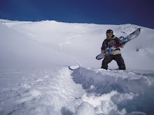
 What can you do on one of those days when a blizzard prevents you from climbing the summits of Cuerda Larga or the Peñalara massif? I think one of the best options is to climb this small summit and descend, heading Southeast, to reach the railway through the pine tree forest that will protect you from bad weather. The descent is short but intense and more than once, after descending it with powder, I´ve thought: “My village is the best there is”. And what a surprise when I study the maps from the Spanish Geographic Institute and I realize that that particular slope doesn´t belong to my village, but to the district of Navacerrada! There isn´t a drop of water on that slope that doesn´t pass through Cercedilla. So I firmly believe the area has to be annexed sooner or later. If any of you can justify the existence of that enclave, then do so. Right now! Although I have to say that however strong your case may be you´ll be wasting your time. I´ll always defend Cercedilla´s claim to that land. In the attached photo you can see the end of the “Telégrafo” chairlift, which is 700 meters from the summit. The photo was taken on February 29th, 2004. The ski resort was closed because it was snowing with hard wind. It was a really good day, with lots of good quality snow. I like days like that.
¿Qué se puede hacer en esos días que la ventisca impide subir a las cumbres de la Cuerda Larga o a las del macizo del Peñalara? Creo que una de las mejores opciones es subir a esta pequeña cima para bajarla en dirección Sureste para llegar hasta la vía del tren por el bosque de pinos que nos resguardará del mal tiempo. La bajada es corta pero intensa y más de una vez, después de descenderla con nieve polvo, he pensado: "mi pueblo es el mejor". ¡Y cuál es mi sorpresa cuando estudio los mapas del Instituto Geográfico Nacional y veo que esa ladera no pertenece a mi pueblo, sino al término municipal de Navacerrada! No hay gota de agua de esta ladera que no pase por Cercedilla, por lo cual creo que dicha zona ha de ser anexionada antes o después. Si alguien puede justificar la existencia de este enclave que lo haga, aunque va a dar igual: con razón o sin ella siempre defenderé la pertenencia de esa zona a Cercedilla. En la foto que he puesto puede verse el final del telesilla "Telégrafo", que está a unos 700 metros de la cima. La foto fue tomada el 29 de febrero de 2004. La estación de esquí estaba cerrada porque nevaba con viento fuerte. Fue un día bueno de verdad, con cantidad y calidad de nieve. Me gustan los días así.
Fué un día bueno de verdad, Nieve en cantidad hasta camorritos. Me flipó la excursión por la vía. Me encanta el flog tío
ResponderEliminar